
Bioregional Maps


Bioregional mapping is process for creating maps that that set cultural and geographic information into natural boundaries and borders, rather than anthropocentric lines removed from context of place. Maps are not neutral, and many maps today are constructed by governments or economic entities to convey their interests and reinforce their world view. Bioregional mapping is a process which lets us reclaim mapmaking for our own purposes and communities.
Through this process, we are able to represent the physical realities and needs for inhabitants within a region, and develop measurable bioregional frameworks for healthier societies able to live within the contexts and constraints of each region.
Some defining features of bioregional maps:
- Every person is an expert, and has something valuable to contribute, to document to share. This can include narratives, histories, stories, things people find special, or knowledge relating to place. Bioregional maps are generally created or defined by communities living within or affected by the topic of the map.
- Temporal. Bioregional maps often include time. How a place changes or is different in each season, or from one year to the next. How animals, glaciers or fish migrate or move. In addition it can map past, present and future – and create roadmaps to societies or things we want to build.
- Bioregional maps can use a wide array of methods to convey information, including song, dance, stories, sign languages, music, social mapping, cognitive mapping, and many other means that individuals feel best able to represent information.
- Many indigenous forms of mapping are inherently bioregional forms of mapping. This includes family and clan relationships, traditional territories and boundaries, relational maps such as to bodies of water, stars and sky.
As a rule, if you see straight lines on a map, whether it is dividing a continent (Africa, Australia etc.), a community (US political districts, gerrymandering), roads (Google Maps) it is not a bioregional map.
Bioregional maps use ‘layers’ that together can better represent a place. These can include:
- Physical: Geology, tectonics, subduction zones, mountains, peaks, ridges, valleys, rainfall, wind patterns, and how they change over time.
- Biotic: Plants, animals, soils. Growing conditions. How animals and plant nations within an area interrelate, and how they change over time.
- Human: Lessons of living in place, indigenous ways of living and knowledge. Culture, economy, politics. agriculture, energy. History, the context and understanding of past and present, and visions for the future that can serve as roadmaps for how we can get to the future.
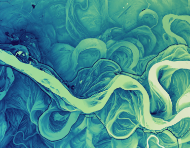
When possible we set the biotic and temporal elements (x axis) within the physical reality of place (y axis) and document how it flows with the passing of time (z axis).
Bioregional maps are not made from one layer of information, but rather atlases in which layer upon layer has been added, from which shapes and deeper lessons emerge.
Mapping Bioregions:


Bioregions have a defined political, economic and spatial territory, defined through natural boundaries and borders, and those living there.
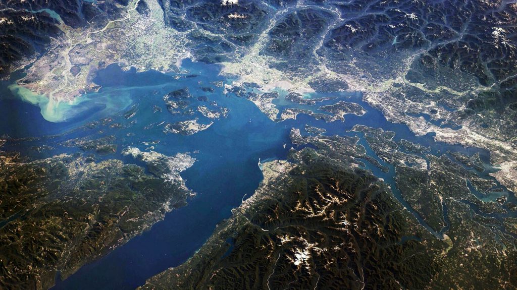
Bioregions are natural countries of the planet. They are the largest sense of scale based on physical place in which those connections make sense. They may contain within them many nations, communities, inhabitants, and ecosystems. We use the natural borders of the bioregion as our base for administrative frameworks because despite cultural differences that arise from these differences, nature acts bioregionally not anthropocentrically.
Whether it is flooding, forest fire, drought, ice pack, disaster preparedness and response, growth strategies, economic integration, transportation planning, energy independence, environment & sustainability, food sovereignty, these are issues which all will act on a bioregional framework. By sharing watersheds – we must all have the ability to impact and affect change, and what one community does, will affect the communities downstream of it.
While many maps are bioregional maps, not all bioregional maps are bioregions. A bioregion is smaller than a continent but larger than an ecoregion. They should be large enough to be self reliant, share interconnected physical geography and inhabitant cultures, and ultimately will be defined by the people living there, even if this does not perfectly match the ecologic realities.
The ultimate purpose of defining bioregions, is to create ecological nations that can use these shared frameworks to create regenerative cultures and economies, and ways of governing that are better representative of people, place and inhabitant.
To map a bioregion, we use
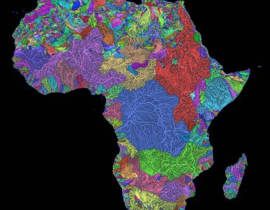
- Geology / Plate Tectonics as our base maps. What are the hard lines? The subduction zones, underwater hydrology, Bioregions are defined through geology. They have hard, jagged lines. They are tectonic, faultlines, geology and whose shapes help conform the ecoregions and biotic life within them. We use bioregions as our frameworks for administrative units because ultimately, nature acts bioregionally. We cannot have any conversation about water, forest fires, drought, salmon recovery or other issues, without involving an entire watershed, and an entire bioregion.
- For internal boundaries we use ecoregions, and groupings of ecoregions if it makes sense to, defined through flora, fauna, topology, rainfall, history (indigenous cultures, histories, language groups – and settler culture, histories, dialects, historical regions etc), agriculture, energy production, urban / rural settings, roads, forests / land use. economic connections, sports, megaregions / intra economic connection – can all play into it.
- Lastly, we can include human inhabitation, and lines as they exist.
Bioregions are similar, but different from ecoregions, in that while being defined by natural borders and features, inhabitant cultures, and especially humans also impact their scale and definition. Ultimately it will be the people living in a place who will define it. For example ‘Pacific Northwest’ is a regional identity that is synonymous with Cascadian values.
Scales of Bioregional Mapping.
- Planet – Earth
- Continent – Defined through the continental crust. Antartica, North America, South America, Africa, Europe, Asia and Australia.
- Terra Region [1] – Used to refer to a collection of one or more bioregions defined by the largest scale of their watersheds, from the start of where a raindrop hits to it’s journey to it’s ultimate terminus. One example is be the watersheds of the Missouri / Mississippi drainage basin, which is so large that it will contain many natural groupings of cultural bioregions and nations. The Cascadia Bioregion, which is both a terraregion and bioregion has both shared culture and is made up of the physical boundaries. The Hawaii Island chain, even though it is comprised of many different watersheds, ecoregions and islands, is considered a bioregion and terraregion because has a shared culture and history within it.
Despite these differences, as long as commonalities such as watershed and environment are shared, there must be at least some form of administrative framework in place for equitable use of commonly shared resources and waterway commons. - Bioregion – Natural countries of the planet. They are defined by 1) starting with the geology + tectonics – and then 2) the systems that emerge from hydrology and rainfall, i.e. watersheds. Soil types. 3) Biotic flora, flauna. Human inhabitation and culture, and how they have altered their lived in. Bioregions can be standalone watershed provinces such as Hawaii or Cascadia, or a Watershed Province might include several bioregions, such as Laurentia, Hudson Bay or Mississippi / Missouri.
- Biotic Provinces – Shared regions of culture, flora and fauna that stem across more than a single ecoregion. Food sheds, fiber sheds, fire sheds. Floodplains are all examples.
- Ecoregions – Shared watersheds of a drainage area with similar types of flora and fauna.
- Watershed Municipalities – Watershed districts within an Ecoregion, either individually, or that combined make up various cities and other major features within ecoregions.
- City Municipalities – Greater city areas and rural areas within a watershed.
- Neighborhood / Community – exist within city or watershed municipalities.
- Individual / Home – the place where our actions start, and in which we have the most control over. The start of our actions, interactions – cultural shifts.
Goal of Bioregionalism:

Bioregionalism seeks to organize economic, political and cultures (lifestyles) to fit within bioregions, and to build interconnected administrative systems within each.
- Politically – Decentralize & rethink political boundaries to shared cultural, physical and geographic realities that can better represent people, inhabitants and place. Embraces consensual relationships, dynamic and fluid borders for how people want to live and how data interelates with each other, set within bioregional realities. We seek to shift boundaries and borders within watershed governances.
- Culturally – Support and embrace lifestyles customized for each bioregion, using indigenous ways of living, knowledge and resources. Understand the historic, cultural and economic history and context of each area and place to develop highly specialized ways of living custom fit for each area community.
- Economically – To create bioregional frameworks for a regenerative economy that is local and sustainable, connected globally in a way that is ethical and accountable, and that puts more back in than it takes out, improves the well being of the place itself over generations. Use the bioregion as a framework to create measurable outcomes and benchmark to determine metrics for success or failure.
Additional Notes:
- Bioregional maps remove arbitrary political boundaries. This can be a layer, but should not be a base map or layer.
- The name of the bioregion should be an “endonym” which means the name for a place, site or location in the language of the people who live there. It should be representative of the whole region, not one particular point, or place or people.
- If you’re interested in generating a bioregional flag – simply create a flag that depicts a direct representation of the landscape, with an icon that helps represent the bioregion or what it represents. This lets the cultural human elements be adaptable for different causes and communities, and the colors to be adaptable for different subregions and geographic representations & color branding.
[1] Terra Region – Coined by Jay Conrad, Brandon Letsinger & Alex DeVetio with the Department of Bioregion in 2019.


Add comment