“A bioregion is defined in terms of the unique overall pattern of natural characteristics that are found in a specific place. The main features are generally found throughout a continuous geographic terrain and include a particular climate, local aspects of seasons, landforms, watersheds, soils, and native plants and animals.” (Peter Berg)
“A bioregion can be determined initially by use of climatology, physiography, animal and plant geography, natural history and other descriptive natural sciences. The final boundaries of a bioregion, however, are best described by the people who have lived within it, through human recognition of the realities of living-in-place.” (Peter Berg & Raymond Dasmann)
“People are also counted as an integral aspect of a place’s life, as can be seen in the ecologically adaptive cultures of early inhabitants, and in the activities of present day reinhabitants who attempt to harmonize in a sustainable way with the place where they live.” (Peter Berg)
“A bioregion refers both to geographical terrain and a terrain of consciousness — to a place and the ideas that have developed about how to live in that place.” (Peter Berg and Raymond Dasmann)
Before moving onward, it is important for us to create a shared definition of exactly what we mean by bioregionalism, and the principles and shared values it stands for when we discuss it.
Bioregionalism at its most simple is a philosophy that connects people and ideas into place, and works watershed by watershed to provide a mechanism which can break large, intangible global issues down to local levels to find solutions to issues; magnify solutions already being practiced in a community, and create accessible pathways for every person living in a region to be able to get active. Each watershed and community will be different, and each region and community will know their needs the best, and be the best to represent those needs.
Bioregions have two distinct elements:
● SCIENTIFIC: defined by the physical landscape – geology, topology, hydrology, plate tectonics, geography, erosion, rainfall, soil type and variation – and the biological beings and ecosystems living with them, each distinct, each suited and evolved slightly differently. In this, we must ask – how is nature different in different areas, what natural diversity make these regions so different? and how does that impact what we should do?
● CULTURAL: the people and inhabitants living within the bioregion. The sum of our personal actions, and interpersonal relationships that make each area distinct – it is the food we grow, what we eat, our sports, music – the clothes we wear, our shared identity, our economy, governments and politics. In this, we must ask – how does where we live affect these things? What are things we can each do, that taken together, will see the world shift in healthier ways, and improve the well being of our communities and bioregion?
A bioregion is a shorthand designation for ‘bio-cultural region’. It is rooted in the idea that culture stems from placed and that human cultures develop in relation to the natural ecosystems they inhabit. Bioregions are defined by characteristics of the natural environment rather than by man-made divisions, and are the sum of the cultures, ecoregions & ecosystems, and watersheds that arise from a particular place. These spaces are the largest areas where a person can walk, and still find connections to other people based on shared place. These physical boundaries, and the geographic, topographic and living flora and fauna all work together to create a ‘bio-region’.
Bioregionalists and bioregional movements use these containers to break down large issues, work with those already out in the community making the changes we need happen, create social, political, economic – and cultural shifts towards healthier communities, and build hubs that connect other people in a bioregion to those solutions. By creating bioregional hubs for every movement around the common shared principles of bioregionalism, we create a framework of action for a decentralized, rapid, voluntary and radical change that our planet needs.
There will be no one right answer, or one right solution. Rather it will be hundreds of solutions working together, adapting to fit different needs of different backgrounds, locations and contexts, to achieve the real change that we want to see.
Watershed, Ecoregion, Bioregion – What’s the deal?
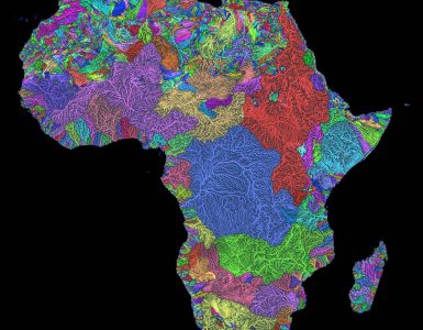
Bioregions are made up of watersheds and ecoregions… but what’s the difference? A watershed is an area of land that drains all the streams and rainfall to a common destination such as a bay, lake or ocean. Watersheds can be large or small, and are often divided by natural ridges and hills. Watersheds are entirely concerned with the travel of water – from where rainfall lands, or underground water runs – all the way on it’s journey to the place it flows no more. Watersheds consists of surface water–lakes, streams, reservoirs, and wetlands–and all the underlying groundwater. Larger watersheds contain many smaller watersheds.
Watersheds are important because the streamflow and the water quality of a river are affected by things, human-induced or not, happening in the land area “above” the river. Watersheds are so critical for bioregionalism because, like Cascadia, they transcend arbitrary borders, and are critical in understanding where our water comes from, and where it goes, as well as engaging
with all of the communities affected by that discussion. Creating these holistic cultural, economic, ecological and democratic systems are why ideas like Cascadia are so important. The largest watershed in North America is the Mississippi River Watershed, which drains 1.15 million square miles from all or parts of 31 U.S. states and two Canadian provinces stretching from the Rockies to the Appalachians.
Ecoregions are comprised of these watersheds, and are used to make up the areas of a bioregion. Ecoregions are similarly defined, but can include several similar watersheds and are expanded to include, physical, biological, and human realities that may stem from these areas. Cascadia in total has 75 ecoregions, reflecting areas of similar flora, fauna, geology, soil composition and rainfall patterns.
Reflecting this, federal policy planners have increasingly shifted to watershed and ecoregional planning frameworks. Government agencies at the regional, state, national and international levels are working to adopt more holistic approaches to stop dealing with single issues, or ‘point-source’ problems, to broader, regional approaches that greater take in an entire area, those most affected, and create better solutions.
Watershed: A watershed is the smallest unit we look at as bioregionalists. It is the area created from where a rain drop falls or a spring bubbles to the surface, to the body of water it connects to. Ecoregions are comprised of these watersheds, and are used to make up the areas of a bioregion. Ecoregions are similarly defined, but are expanded to include, physical, biological, and human realities that may stem from these areas. Watersheds, like Cascadia, transcend arbitrary borders, and are critical in understanding where our water comes from, and where it goes, as well as engaging with all of the communities affected by that discussion. Creating these holistic cultural, economic, ecological and democratic systems are why ideas like Cascadia are so important. The Columbia River watershed alone, the largest in Cascadia, includes parts of six US states and one Canadian province. Its border is traced, “not by governments or treaties, but by every drop of liquid that finds a common path to the ocean”
Ecoregion: Ecoregions are another way to say ‘ecosystem’ – an area with characteristic flora, fauna, and climatic conditions – and can be comprised of several different watersheds, if the plants and animals are similar. Humans settlement patterns are included within an ecoregion, because humans have a large impact on their surrounding ecosystem, and in reverse, ecosystem plays a large part in how humans adapt, settle and build. In terms of size, an ecoregion is larger than a watershed and smaller than a bioregion; or in political terms, larger than a county and smaller than a state or province. There are 75 ecoregions in Cascadia, and of the more than 750,000 square miles of Cascadia, ecoregions average about 10,000 square miles each, though ranging from 2,000 to over 30,000 square miles. Ultimately the size of each depends upon the unique character and context of the place itself. Reflecting this, policy planners have increasingly shifted to watershed and ecoregional planning frameworks to create a more holistic approach to stop dealing with single issues, or ‘point-source’ problems, to broader, regional approaches that greater take in an entire area, those most affected, and create better solutions
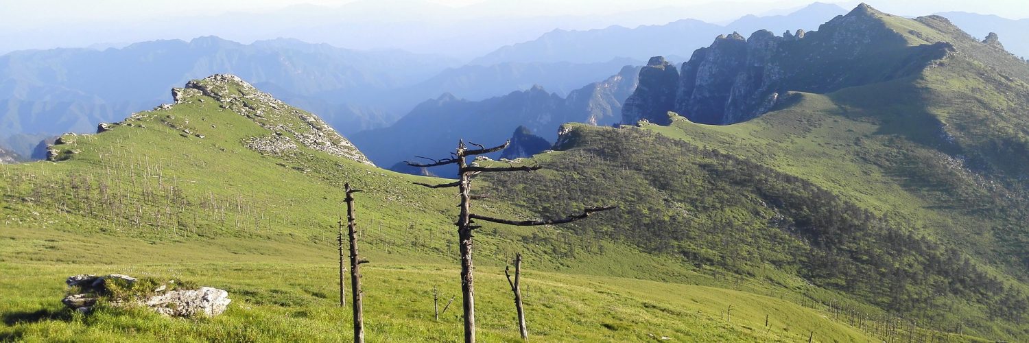
Bioregion: Lastly, we use the scale of the bioregion – a region whose limits are naturally defined by topographic features (such as mountain ranges and rivers) and biological features (such as plants, animals, humans and entire ecosystems). Culture is a sum of our personal and interpersonal relationships and choices, many of which are defined shared values and need which arise from sharing a place. A bioregion is the most efficient, and largest physical scale on which these cultural connections that arise from place will make sense and serve as containers on which to break down large, intangible issues, onto a local level from which every person can walk out their door, and get active. It must necessarily include each watershed within it, because you cannot have a discussion about only parts of each. Cascadia is a land of flowing waters, and for the Cascadia bioregion, it is the topographic region that is defined from which a drop of rain hits the western side of the continental divide – and flows into the Pacific – from the headwaters of the Fraser and Columbia, to the headwaters of the Snake, which stems from the Yellowstone caldera.