

Definitions of Bioregion:
A bioregion is an living mosaic and area defined area smaller than a biogeographic realm but larger than an ecoregion or an ecosystem, and is defined along watershed and hydrological boundaries using physical, ecological and cultural layers. A bioregion uses the starting blocks of watersheds, using a combination of layers, beginning with the oldest “hard” lines: geology, topography, tectonics, wind, fracture zones, and continental divides, working its way through the “soft” lines: living systems such as soil, ecosystems, climate, marine life, and flora and fauna, and lastly the “human” lines: human geography, energy, transportation, agriculture, food, music, language, history, Indigenous cultures, and ways of living within the context set into a place, and it’s limited to determine the final edges and boundaries.
This is summed up well by David McCloskey, author of the Cascadia Bioregion map:
“A bioregion may be analyzed on physical, biological, and cultural levels. First, we map the landforms, geology, climate, and hydrology and how these environmental factors work together to create a standard template for life in that particular place. Second, we map the flora and fauna, especially the characteristic vegetative communities, and link them to their habitats. Third, we look at native peoples, western settlements, and current land-use patterns and problems in interaction with the first two levels.”
A bioregion is defined as the largest physical boundaries where connections based on that place will make sense. The basic units of a bioregion are watersheds and hydrological basins, and a bioregion will always maintain the natural continuity and full extent of a watershed. While a bioregion may stretch across many watersheds, it will never divide or separate a water basin. A bioregion is a shorthand designation for a ‘bio-cultural region.’ It is rooted in the idea that culture stems from place and that human cultures develop in relation to the natural ecosystems they inhabit. Bioregions are defined by characteristics of the natural environment rather than by man-made divisions and are the sum of the cultures, ecoregions & ecosystems, and watersheds that arise from a particular place. These spaces are the largest areas where a person can walk and still find connections to other people based on shared place. These physical boundaries, and the geographic, topographic and living flora and fauna all work together to create a ‘bio-region’.
Bioregions emerge from the Landscape.
Unlike arbitrary lines on maps, bioregions exist. Right now. Look at a map of your area from space – and you will quickly become an expert of your place. Most importantly, unlike many maps – bioregions are not just created with simple “lines” on maps – rather they emerge from the realities of place, of many different layers of stewardship coming together to help shape the curves and flows of life in a place. They include the oldest stories of place – the jagged edges of continental plates jamming into each other – subduction zones, fissures, fractures, mountain ranges – and from that how does that guide the energy of a place? Rain, wind, soil and ecosystems – plants, animals, fish – and from that how human cultures have adapted to that place? More than anything else – a bioregion is simply a whole system lens for answering that question.

While bioregions exist for humans, every plant or animal has a bioregion or a zone of territory that presents the optimal conditions for them to reside, exist, and thrive – and includes layers such as predators, prey, and the physical extent that they may be found in. Each person or community may have a small, personal bioregion in which their daily life place extends – but the cultural element is just as important. For example, what is the bioregion of a salmon, an elk, an orca or a falcon? While the specific animal might exist in a specific ecosystem – the entire watersheds and webs of life for that animal must be included as part of a bioregion. The process of creating a bioregional map – is just as important as the map itself – which will be a living document – that is not static – rather, it changes and evolves.
The Context of Bioregion: Peter Berg & Raymond Dasmann
The term bioregion as we use it was initially coined by Allen Van Newkirk in 1972 in his article Bioregions: Towards Bioregional Strategies for Human Culture, Environmental Conservation in 1975. Raymond Dasmann and Peter Berg, who founded the Planet Drum Foundation in 1973, carried it forward and developed it. The foundation is located in San Francisco and just celebrated its 50th anniversary in 2023. Planet Drum, from their website, defines a bioregion as:
“a distinct area with coherent and interconnected plant and animal communities, including human and natural systems, often defined by a watershed. A bioregion is a whole ‘life-place’ with unique requirements for human inhabitation so that it will not be disrupted and injured.”
Peter Berg defined a bioregion at the Symposium on Biodiversity of Northwestern California, October 28–30, 1991:
“A bioregion can be determined initially by the use of climatology, physiography, animal and plant geography, natural history and other descriptive natural sciences. The final boundaries of a bioregion are best described by the people who have lived within it, through human recognition of the realities of living-in-place. All life on the planet is interconnected in a few obvious ways, and in many more that remain barely explored. But there is a distinct resonance among living things and the factors which influence them that occurs specifically within each separate place on the planet. Discovering and describing that resonance is a way to describe a bioregion.”
Bioregions have a Definition
As nation state and traditional western economic institutions begin to fail, bioregionalism and bioregions are experiences a moment across the world right now. Many people are coming across the idea of bioregions and bioregionalism and becoming excited, looking to connect the idea with their passion and work – though not necessarily familiar with the definition. While this is wonderful – if not tended, this can create confusion and incoherence in the field. We are lucky enough that we are having a moment, and have a window to grow a new movement for that can help guide us to a regenerative future for our planet – that might, just might see humans surviving polycrisis, and trying to build a resilient future for our children.
But why does it matter to have a shared definition of bioregion we can agree on? – Shared definitions and context help us grow and build a coherent movement, with shared values, principles and north start. It means that we can trust and build relationships with any other bioregional movement, group, organizer or group around the world – and know that we are aligned, and working towards a similar, regenerative goal. Without this – it allows for people to come in and co-opt the term, even when well intentioned, and begin using it often ignorant of the meaning, context, or history that led the idea or term. One of my favorite quotes on why shared definitions are important actually comes from Neil de Grasse Tyson in talking in his podcast on Startalk about the important of kicking Pluto out of our astrological family of planets:
TYSON: And in 2006, an official vote was taken of the International Astronomical Union. It’s just the group of international astrophysicists, which has a nomenclature committee to adjudicate this sort of thing. And they officially sent Pluto from a planet status to a dwarf-planet status. And I think Pluto’s happier there actually.
LEVITT: Since when is science done by a vote? Imagine if they voted on whether Darwin’s theory was right or Copernicus’s theory was right? Number one, they would have voted the wrong way —
TYSON: We’re not voting on what science is true or not. We’re voting on nomenclature. You can’t really communicate unless everyone knows what the nomenclature is. If you discover a comet, what are the rules for naming a comet so that there’s consistency? What are the units of measure we should use when we’re talking about this phenomenon in the universe versus that? And so the question was given that the word “planet” was never formally defined since ancient times. In fact, the last time it was defined unambiguously was when “planet” — from the Greek planétés, meaning wanderer — when we had the seven wanderers, the sun, the moon, Mercury, Venus, Mars, Jupiter, and Saturn. That’s the last time it was defined unambiguously. So they created categories of planets. If I say “dwarf planet,” you will know the object is large enough to be spherical, because gravity makes that happen, but not so large that it owns its band around the sun. There are thousands of other objects orbiting the solar system at Pluto’s distance. It does not command a space the way what we’re calling planets do. Henceforth, Pluto’s a dwarf planet. There’s an asteroid called Ceres, which was big enough to be a sphere. That got promoted from being an asteroid to a dwarf planet. Now, if you want to just call everything that orbits a star a planet, I don’t have a problem with that. It just renders the word completely useless. After you say, “I discovered a planet orbiting a star,” then we have to play 20 questions before I even know what kind of object you’re talking about.
And hence. Naming matters.
Peter Berg and Raymond Dasmann helped define Bioregions as something different than how they had been used in a strictly scientific sense – i.e. the One Planet map of Ecoregions – and instead Peter Berg gave his famous quote, which people love to pull part of – but seem to ignore the rest that –
“The term bioregion has been defined differently than in a strictly natural sciences sense. It refers to both a geographical terrain and a realm of consciousness. A bioregion can be determined initially by use of climateology, physiography, animal and plant geography, and other aspects of natural history, but the final borders are best described by the people who have lived within it, through human recognition of the realities of living-in-place.”

Peter Berg and Raymond Dasmann wrote this definition in 1977, and published it as part the book Reinhabiting California. For Raymond Dasmann, an environmental conservationist who had studied under Aldo Leopold, and then worked with the UN International Union of the Conservation Nation (IUCN) with Miklos Uvardy from University of British Columbia to create some of the first maps of biogeographic provinces in 1973 and 1975, started the Man and Biosphere (MAB) project, and helped coin the term “biodiversity” – renaming bioregions to include physical realities such as watersheds, ecosystems and human cultures was critical to putting people back into place, rather than removed from it. This idea of bioregion was a counter-narrative to the way it was being used by a small group of academics, the problems Raymond saw with biogeographic provinces – that they ignored humans and the whole environment – and what Peter Berg had witnessed at the first UN summit on the human environment in 1972, of tens of thousands of indigenous, environmental, anti-war, anti-nuclear people he termed the “planetariat” – who were not being represented by the men in business suites inside the halls of power. This would be the defining moment that sparked him to launch Planet drum a year later.
Kirkpatrick Sale, another early pioneer of the idea of bioregions, defined it in 1974 by declaring that:
“A bioregion is a part of the earth’s surface whose rough boundaries are determined by natural and human dictates, distinguishable from other areas by attributes of flora, fauna, water, climate, soils and land-forms, and human settlements and cultures those attributes give rise to. The borders between such areas are usually not rigid – nature works with more flexibility and fluidity than that – but the general contours of the regions themselves are not hard to identify, and indeed will probably be felt, understood, sensed or in some way known to many inhabitants, and particularly those still rooted in the land.”
If you’re looking to use the term bioregions as part of the bioregional movement, first understand that this is not a map of the bioregions of the world. There is no “map” of the world’s bioregions – because we haven’t created it yet. Efforts like One Earth to label maps of bioregions are simply using ecoregion data – and calling them bioregions (again – creating incoherence and confusion in the field), and is from a small group of people who got together and said, here it is – here’s the map. Ignored in this mapping process – physical realities of place – and indigenous cultures and ways of living since time immemorial, as well as human cultures which currently move more dirt then nature.
Bioregionalism says that humans are a keystone species, and need to be put back into visions, plans and maps of our place, and that this separation of human from their environment and ecosystem – is actually one of the most damaging things that western science has done. For us here in Cascadia, we use a simple rule which is called – call it what it is. If it is a city – call it a city. If it is a watershed, call it a watershed. If it is an ecoregion or biome – call it an ecoregion or biome. If it is a bioregion – i.e. a whole system lens that includes at least one intact watershed, the regional ecosystems within that watershed – and has been given definition and shape by the people living there because it best represents the realities of that place – then call it a bioregion.
Reinhabitation is the process of becoming aware of the intricate relational web of a bioregion’s ecological qualities and inhabitants, the “biotic community,” as Berg puts it. One can begin by learning the local watershed — the area defined by the common point where all local water flows eventually end.
Bioregions are important because nature acts on the scale of watersheds, ecoregions, and bioregions and does not stop at the edge of a private property line or arbitrary national border. Rather than just one layer or set of lines on a map, bioregions emerge from many layers of information. They can be used to create cohesive frameworks of stewardship that are set within the many contexts of a place.
Bioregions have two distinct elements:
SCIENTIFIC: defined by the physical landscape – geology, topology, hydrology, plate tectonics, geography, erosion, rainfall, soil type and variation – and the biological beings and ecosystems living with them, each distinct, each suited and evolved slightly differently. In this, we must ask – how is nature different in different areas, what natural diversity make these regions so different? and how does that impact what we should do?
CULTURAL: the people and inhabitants living within the bioregion. The sum of our personal actions, and interpersonal relationships that make each area distinct – it is the food we grow, what we eat, our sports, music – the clothes we wear, our shared identity, our economy, governments and politics. In this, we must ask – how does where we live affect these things? What are things we can each do, that taken together, will see the world shift in healthier ways, and improve the well being of our communities and bioregion?
How do we map a Bioregion?
For our purposes, we are concerned with mapping human bioregions, or bioregions that help humans grow and live in the context of place and can develop a bioregional culture that allows humans to exist as a positive and regenerative force within the places they call home.
Peter Berg, as part of his early work with Planet Drum, laid out a beautiful and simple process for thinking about how we map bioregions and find our bioregion address:
Reinhabitation is the process of becoming aware of the intricate relational web of a bioregion’s ecological qualities and inhabitants, the “biotic community,” as Berg puts it. One can begin by learning the local watershed — the area defined by the common point where all local water flows eventually end.From there, ask simple questions that connect you tangibly both to your locality and to wider systems. Questions like: what are my closest native plants, animals, berries, and grasses? What is the average rainfall for this time of year? Where does my garbage go? Where does my water come from? Where does my power come from?
Ecologies are nested: ascending in scale from local ecosystem, to watershed, to bioregion, and onwards to continent and planet.
One powerful way to understand this is to think about your own bioregional address. “I say that I live in the Islais Creek Watershed, of the San Francisco Bay Estuary, of the Shasta Bioregion, of the North Pacific Rim, of the Pacific Basin, in the planetary biosphere of the universe,” said Berg. Gary Snyder, an early bioregionalist and poet, reports his location as being “on the western slope of the northern Sierra Nevada, in the Yuba River watershed, north of the south fork at the three-thousand-foot elevation, in a community of Black Oak, Incense Cedar, Madrone, Douglas Fir, and Ponderosa Pine.” A bioregional address is about grounded physical, observable reality rather than national or ideological abstractions. Source
This was also spoken to well by David McCloskey:
“While there are few straight lines in nature, there are many definite and powerful edges—various ecotones, watershed divides, climatic zones, fault lines and scarps. Careful attention should be given to such beginnings and endings, for these dramatic turnings in the earth serve as clear and powerful articulations of diversity.”
David McCloskey, On Bioregional Boundaries)
The external boundaries of a bioregion are hard and jagged, mountain ranges, fault lines, geology, and hydrology – and from these hard edges, interconnected systems of rivers, weather patterns, ecosystems, and soil types all define the shapes of our bioregion. This includes watersheds, ecosystems, and human communities.
Such an area must be large enough to maintain the integrity of the region’s biological communities, habitats, and ecosystems; to support important ecological processes, such as nutrient and waste cycling, migration, and stream flow; and to include the human communities involved in the management, use, and understanding of biological resources. It must be small enough for local residents to consider it home.
A bioregion is unique in that it’s not just defined by natural borders, but also by the people living there. It must have a unique cultural affinity and means that the livelihoods and interests of local communities should be the starting point and criteria for regional solutions and conservation.
Four Basic Thresholds for Determining a Bioregion
- A bioregion is a land and water territory whose limits are defined by the natural realities of a place and the communities within them, and is the largest geographical limits where connections based on place will make sense.
- Such an area must be large enough to be self-reliant and maintain the integrity of its biological communities, habitats, and ecosystems.
- Watersheds and Drainage Basins are the building blocks of a bioregion. Because biological communities and cultures are interconnected, a whole systems approach is needed. Bioregions might extend “across” watersheds, but they will never be divided.
- People Matter. Ultimately, it is up to the people and inhabitants of a bioregion to determine what stewardship frameworks make sense for that area, what best represents them, and their way of life and living. In addition, people can and often do fundamentally change their natural environments. Often, whether they realize it or not, bioregions provide the basis for inhabitant cultures, identities that stem from the place that can help determine or shape these boundaries.
While many maps are bioregional maps, not all bioregional maps are bioregions.
A bioregion is smaller than a continent but larger than an ecoregion or watershed. They should be large enough to be self-reliant and share interconnected physical geography and inhabitant cultures.
What a Bioregion is not:
An arbitrary line on a map. A nation-state. A state or province. A single ecosystem or ecoregion within a rich tapestry of ecosystems. A county. A city. The word bioregion has a meaning.
Scales that we use for Regenerate Cascadia
- Planet – Earth
- Continent – Defined through the continental crust. Antartica, North America, South America, Africa, Europe, Asia and Australia.
- Bioregion – Shaped from the Continental divides—natural countries of the planet. Large hydrological basins that are the largest scale and sense of connection, based on place and physical realities that make sense, and that will have to have shared frameworks of stewardship working together within them. i.e. Cascadia bioregion.
- Major Watershed – Major watersheds within a bioregion are larger than an ecoregion. i.e. Columbia river.
- Ecoregion/Ecosystems – Shared watersheds of a drainage area with similar types of flora and fauna. i.e. the Salish Sea.
- Smaller Watersheds – Watersheds within an Ecoregion, either individually or combined make up various cities and other major features within ecoregions. i.e. Cedear or Green River.
- “Discrete Landscape” – Our home. a collection of one or more watersheds that we directly steward. The scale on which we take action and a landscape within an ecoregion or watershed where it makes sense to work together. i.e. Whidbey Island.
Bioregions as a part of Bioregionalism
The definition and idea of a bioregion emerged from and form the foundation for a set of ethics, and philosophy called Bioregionalism.
As the environmental movement developed in the 1970s, a counter-current called bioregionalism emerged. Developing primarily in Western North America, this movement sought to address environmental issues through a politics, practice, emerging community, and personal identity based on a local and ecologically attuned sense of place. Early bioregionalists felt such an approach might prove more fruitful than efforts focused at the national and international levels.
In the early 1970s, the contemporary vision of bioregionalism began to be formed through collaboration between natural scientists, social and environmental activists, artists and writers, community leaders, and back-to-the-landers who worked directly with natural resources. They wanted to do “more than just save what’s left” regarding nature, wildness, and the biosphere. During the 1970s, Planet Drum Foundation in San Francisco became a voice for this sentiment through its publications about applying place-based ideas to environmental practices, society, cultural expressions, philosophy, politics, and other subjects. By the late 70s, bioregional organizations such as the Frisco Bay Mussel Group in northern California and the Ozark Area Community Congress on the Kansas-Missouri border were founded to articulate local economic, social, political, and cultural agendas. The Mussel Group eventually played a pivotal role in persuading the public to vote down a bioregionally lethal Peripheral Canal proposal to divert fresh water away from San Francisco Bay. The Ozarks group has held annual gatherings to promote and support place-based activities. Hundreds of similar groups (and publications) exist in North and South America, Europe, Japan, and Australia.
Environmental activist and one of the original Diggers, Peter Berg, for example, had attended the 1972 UN conference on the environment in Stockholm and came away convinced that such global gatherings and institutions were not going to solve the problem, indeed to some degree they very much were the problem. Throughout the late 1970s and early 1980s, he and other like-minded individuals, including Judy Goldhaft, Raymond Dasmann, Kirkpatrick Sale, Judith Plant, Eleanor Wright, Doug Aberley, Stephanie Mills, Jim Dodge, Freeman House, Van Andruss, David Haenke, and Gary Snyder, sought to create a locally rooted environmental movement, one they decided to call bioregionalism, from the ground up. This new form of environmentalism was not reactive, responding to every all-too-frequent threat or calamity, but pro-active, seeking to create the conditions for a more ecologically suitable world in which such threats and calamities were avoided.
Cheryll Glotfelty and Eve Quesnel explain in their recent compilation of Berg’s writing, The Biosphere and the Bioregion, in 1977, Berg and ecologist Raymond Dasmann published an article titled “Reinhabiting California.” This manifesto defined bioregions as places related to but distinct from the biogeographical provinces that ecologists and geographers had been developing by adding a cultural dimension to the geographical concept. A bioregion, they offered, “refers both to geographical terrain and a terrain of consciousness—to a place and the ideas that have developed about how to live in that place.”
Because it is a cultural idea, the description of a specific bioregion is drawn using information from the natural sciences and many other sources. It is a geographic terrain and a terrain of consciousness]. Anthropological studies, historical accounts, social developments, customs, traditions, and arts can all play a part. Bioregionalism utilizes them to accomplish three main goals:
- restore and maintain local natural systems;
- practice sustainable ways to satisfy basic human needs such as food, water, shelter, and materials; and
- support the work of reinhabitation.
The latter is accomplished through proactive projects, employment and education, and by engaging in protests against the destruction of natural elements in a life-place.
Bioregional goals play out in a spectrum of different ways for different places. In North America, for example, restoring native prairie grasses is a basic ecosystem-rebuilding activity for reinhabitants of the Kansas Area Watershed Bioregion in the Midwest, whereas bringing back salmon runs has a high priority for Shasta Bioregion in northern California. Using geothermal and wind as renewable energy sources fits Cascadia Bioregion in the rainy Pacific Northwest. Less cloudy skies in the Southwest’s sparsely vegetated Sonoran Desert Bioregion make direct solar energy a more plentiful alternative there. Education about local natural characteristics and conditions varies from place to place, along with bioregionally significant social and political issues.
Bioregions as a part of Bioregional Mapping
Bioregional mapping is a community and participatory process to create maps that combine ecological and physical information with social and cultural information within a given place, as defined by those living there or the communities most impacted. It is both a tradition that dates back thousands of years, inspired by countless forms of Indigenous Mapping, and also that has emerged as a direct and modern response to the erasure of local cultures in the face of our current ecological, economic and social crises.
While not every map will be at the scale of a bioregion, if you extend mapping beyond the parcel level or from a national or arbitrary boundary to a neighborhood, natural, watershed or other region that shares biological and cultural boundaries, you are creating a bioregional map.
Bioregional mapping is the art of making people care.
The goal of bioregional mapping is to help humans collectively re-inhabit the continents and bioregions that they live within. It encourages lifestyles that are healthy and democratic, self resilient communities living within the a sustainable carrying capacity for their area, and more so working to actively regenerate their region and world. It is also a deeply personal tool, as a person charts their own experiences, getting to know their home places, and makes every person an expert, and a part of this process.
As a place based ethic, bioregionalism fundamentally challenges us to rethink our relationship to each other and the places that we live, not just along human made lines, but in ways that consider the interconnected whole; all inhabitants, not just the humans living within a place. Because of this, bioregional mapping is a fundamental tool of bioregionalism. With it, we can map our water comes from, different communities of inhabitants who might affected, who originally lived where they now do, where their food comes from, where their waste goes; local plants, animals and how these might change with the seasons.
While it seems simple, these first steps that a bioregionalists takes can be incredibly powerful, revolutionary to some. Most importantly, by helping someone to better know their home, it challenges us to reconceive how we relate to a place, breaks down established mental and physical boundaries and if done properly, and most importantly, can get someone to care. By taking these first steps, we cease to be American or Canadian and become citizens of our neighborhood, our watersheds, bioregions and places that are meaningful to us.
Bioregional maps are effective because culture stems from the shared experiences and concerns that grow from sharing place. They employ the knowledge and wisdom gained from understanding experiences with niche ecosystems of place.
Beyond a map on a screen, or lines on paper, bioregional maps can be stories told around a campfire, sung, danced, quilted, painted, posted or however best communicates the purpose that participants want to communicate. One important feature is that bioregional maps are also often concerned with with time – stories from the past, things that people find important to share or groups that are making a difference today, and lastly mapping regenerative and sustainable futures that we want to see. From these community maps, we can create road maps to ideas that might not have existed before, with tangible steps for how to get there. Bioregional mapping tends to be concerned with everything that current mapping is not – everything left off of google maps, or in between the road maps of interstates, gas stations and fast food restaurants.
The plants, the trees, the animals, our stories and lived experiences. Everything that makes a place special. The last little batch of old growth in a neighborhood, the last hawthorne bush planted by your grandmother, the crazy lady with the chickens next door, the homeless encampment down the way, or colorful mural. Untold and forgotten histories of discrimination, genocide or earlier strategies of resistance more important than ever now to tell. Or maybe it’s the type of birds or fish that migrate with the type of season. The rivers that carry the fish, or the bushes that provide unique nesting for native bird species. Stories of the places that make living here special, that define what we think of as home.
These new maps, with our own values, stories, perspectives, and world observations, can be the starting point of future work in these new regions. By starting with communities in each watershed, which will have distinct needs and shared concerns that stem from that place, and creating a dialogue that spans along an entire watershed, bioregional systems and organizing create a more systemic and holistic approach to solving many of the regions, and worlds most significant challenges.
Ultimately, we will never accomplish real change by working within the cartography of capitalism or the nation state, nor will we be able to achieve a future that we cannot clearly envision or articulate. Instead, new maps will be needed, and new processes that involve all of us required. Just as we must work to democratize the ways we live and the societies we live in, a new form of map making is needed.
By mapping our home places, and the things we find special, we challenge these perceived notions, and chart pathways to new realities and futures for how our society can live.
Watershed, Ecoregion, Bioregion – What’s the deal?
Bioregions are made up of watersheds and ecoregions… but what’s the difference?
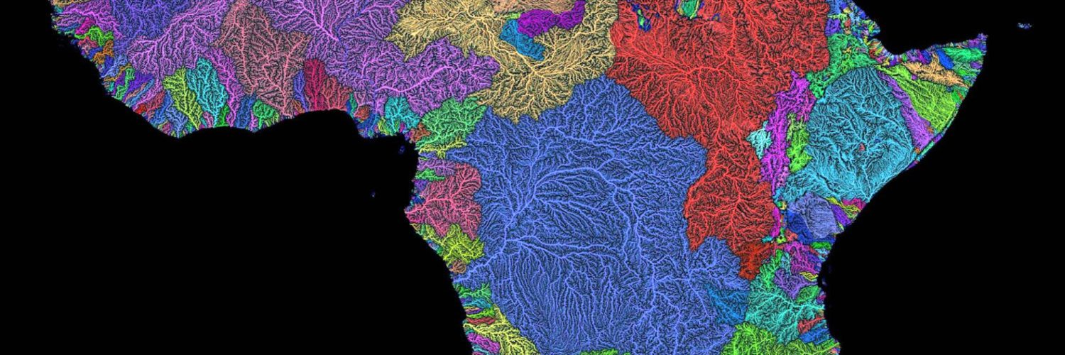
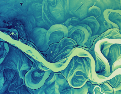
Watersheds
A watershed is an area of land that drains all the streams and rainfall to a common destination such as a bay, lake or ocean. Watersheds can be large or small, and are often divided by natural ridges and hills. Watersheds are entirely concerned with the travel of water – from where rainfall lands, or underground water runs – all the way on it’s journey to the place it flows no more. Watersheds consists of surface water–lakes, streams, reservoirs, and wetlands–and all the underlying groundwater. Larger watersheds contain many smaller watersheds.
A watershed is the smallest unit we look at as bioregionalists. It is the area created from where a rain drop falls or a spring bubbles to the surface, to the body of water it connects to. Ecoregions are comprised of these watersheds, and are used to make up the areas of a bioregion. Ecoregions are similarly defined, but are expanded to include, physical, biological, and human realities that may stem from these areas. Watersheds, like Cascadia, transcend arbitrary borders, and are critical in understanding where our water comes from, and where it goes, as well as engaging with all of the communities affected by that discussion. Creating these holistic cultural, economic, ecological and democratic systems are why ideas like Cascadia are so important. The Columbia River watershed alone, the largest in Cascadia, includes parts of six US states and one Canadian province. Its border is traced, “not by governments or treaties, but by every drop of liquid that finds a common path to the ocean”
Watersheds are important because the streamflow and the water quality of a river are affected by things, human-induced or not, happening in the land area “above” the river. Watersheds are so critical for bioregionalism because, like Cascadia, they transcend arbitrary borders, and are critical in understanding where our water comes from, and where it goes, as well as engaging with all of the communities affected by that discussion. Creating these holistic cultural, economic, ecological and democratic systems are why ideas like Cascadia are so important. The largest watershed in North America is the Mississippi River Watershed, which drains 1.15 million square miles from all or parts of 31 U.S. states and two Canadian provinces stretching from the Rockies to the Appalachians.
Reflecting this, federal policy planners have increasingly shifted to watershed and ecoregional planning frameworks. Government agencies at the regional, state, national and international levels are working to adopt more holistic approaches to stop dealing with single issues, or ‘point-source’ problems, to broader, regional approaches that greater take in an entire area, those most affected, and create better solutions.
Ecoregions
Ecoregions are the rooms in the house of a bioregion, and each bioregion is composed of watersheds and ecoregions. Ecoregion is short-hand for regional ecosystem. An ecoregion is a relatively similar area united by common geography, ecology, and culture. Ecoregions are distinct places that help articulate the internal diversity of a large and complex region.
The purpose of ecoregional mapping is two-fold: one, to provide a common, integrative framework for management of natural resources, and two, for deeper social identification with the land and each other, and thus, better political organization. An ecoregion is known in two ways: internally by its distinctive character (e.g. the Okanogan Highlands), and externally by its context in the region (e.g. Okanogan in relation to the Columbia Plateau).
Each layer of information is brought together to represent the regional system. No one single factor (e.g. climate) explains everything. The inner structure of an ecoregion is organized as a series of intersecting gradients, temperature and precipitation changing with elevation, in alternating belts of vegetation along windward and leeward sides of a parallel series of mountain ranges, with biodiversity thinning toward the edges. Such flows of energy, matter, and information form a distinctive matrix. To understand the region, we must comprehend this system of relationships.
Boundaries are natural and often found as soft transitional areas rather than hard-edged political lines on a map. The boundary is a convergent threshold where many layers intersect, located where several significant factors end and begin. Borders articulate the natural envelope of the place–its centers and bounds–and link this diversity to the larger world.
Since ecological systems are open and lack definite boundaries in complex terrain, watersheds are often used to represent ecosystems on a landscape level. Here, ecoregions are often drawn as a series of contiguous watersheds with similar character and context. However, watershed lines may be crossed when other factors predominate–such as landforms, tectonic suites, regional rivers, vegetative breaks, or major cultural boundaries. In each case, the key is to be true to the land and its people.
A key difference between an ecoregion and a bioregion is that while ecoregions are based on general biophysical and ecosystem data, human settlement and cultural patterns play a crucial role in defining a bioregion. In terms of size, an ecoregion is larger than a watershed and smaller than a bioregion.
The Cascadia Bioregion
One of the best examples of a complete bioregion is the Cascadia Bioregion, located along the Northwestern rim of North America. The Cascadia bioregion contains 75 distinct ecoregions, and extends for more than 2,500 miles (4,000 km) from the Copper River in Southern Alaska, to Cape Mendocino, approximately 200 miles north of San Francisco, and east as far as the Yellowstone Caldera and continental divide.
The Cascadia Bioregion encompasses all of the state of Washington, all but the southeastern corner of Idaho, and portions of Oregon, California, Nevada, Utah, Wyoming, Montana, Alaska, Yukon, and British Columbia. Bioregions are geographically based areas defined by land or soil composition, watershed, climate, flora, and fauna. The Cascadia Bioregion claims the entire watershed of the Columbia River (as far as the Continental Divide), as well as the Cascade Range from Northern California well into Canada. It’s also considered to include the associated ocean and seas and their ecosystems out to the continental slope. The delineation of a bioregion has environmental stewardship as its primary goal, with the belief that political boundaries should match ecological and cultural boundaries.
The name “Cascadia” was first applied to the whole geologic region by Bates McKee in his 1972 geology textbook Cascadia; the geologic evolution of the Pacific Northwest. Later the name was adopted by David McCloskey, a Seattle University sociology professor, to describe it as a bioregion. McCloskey describes Cascadia as “a land of falling waters.” He notes the blending of the natural integrity and the sociocultural unity that gives Cascadia its definition.
Why is this important to have a clear idea of what a bioregion is, or a shared definition?
For the most part, this idea of bioregions and bioregionalism is important because many industrialized areas have spent the last several hundred years erasing these connections to place and bioregional cultures. New bioregional identities and movements have yet to or are just starting to re-emerge. Everything we are doing has to be created, reconnected, and renewed. Right now, from a practical standpoint, traditional knowledge and land stewards have been marginalized, regenerative cultures living within a place largely erased, and so beyond “go into the world and do it yourself,” – we don’t have a lot of tools to say – here is what it is, how you can connect with it, and how we grow this idea beyond abstract ideas, scattered examples of success, that can inspire or change systems.
Bioregions serve as an intermediary between large, global, and intangible issues – that can seem daunting, vague, and overwhelming to the local, where people can walk out their front door and be engaged in the issues they find important. These bioregional scales can be used as a framework to measure the success and failure of sustainability and carbon neutrality. How much can a bioregion store, recycle, mitigate, and set natural limits for growth? How can it meet the habitat requirements of keystone and indicator species, including human communities and the development of place-appropriate technologies and ways of living?
Despite the internal differences within a bioregion, all of them must have some form of common connection in bioregional governance because, ultimately, every community impacted along that waterway must be included in at least some basic level of decision-making. These regions are not static. Instead, their borders are constantly changing, and these changes give a bioregion the ability to adapt in the face of massive external or internal variation.
We desperately need these pathways, networks, and frameworks for a rapid paradigm shift that anyone can hook into, no matter where they live, their background, or the time they have available. Lastly, we must be able to build these systems and propagate these ideas faster than counterparts who have the power to undo our work with the swipe of a pen or large corporate or government agencies that use these regimes to reinforce capital, rather than to fundamentally rethink, dismantle and alter it. Where this becomes a problem is when governments or businesses who have little connection or care about the fundamental philosophy of bioregionalism – use these frameworks disconnected from the idea, from a centralized outside, top-down approach, which can co-opt these nascent ideas.
People most impacted by decisions in an area must be a central facet of decisions made about that area. If these maps are being used for important policy decisions, it can be worse if people are excluded from planning or development, left off of the map as it were – as it can lead to forms of ecological fascism or exclusion of specifically adapted cultures and ways of living within a place. In a world in which money can often speak the loudest and influence the most people, bioregionalists must do the work to dig deep, find our definitions, values, and principles, and then hold to them.
References[edit]
- ^ Thayer, Robert (2003). LifePlace: Bioregional Thought and Practice. Berkeley: University of California. ISBN 9780520236288.
- ^ “What is a bioregion?”. LocalScale.org. Retrieved 2 March 2024.
- ^ “Defining a Bioregion”. Cascadia Department of Bioregion. Retrieved 2 March 2024.
- ^ “What is a bioregion?”. www.ibiblio.org. Retrieved 2 March 2024.
- ^ brandonletsinger (5 December 2020). “Defining a ‘Bioregion'”. Brandon Letsinger. Retrieved 2 March 2024.
- ^ Jump up to:a b c d e f “Cascadia, Geography of Bioregion, Name, Flag, Images & Maps, Philosophy, etc”. cascadia-institute.org. Retrieved 16 December 2016.
- ^ “Ecoregions vs Watersheds – Department of Bioregion”. Retrieved 2 March 2024.
- ^ Vilhena, D., Antonelli, A. (2015). proach for identifying and delimiting biogeographical regions. Nature Communications 6, 6848, [1].
- ^ Ecological Framework of Canada – Levels of Generalization
- ^ Berg, P. and Dasmann, R. (1977). Reinhabiting California. The Ecologist 7 (10): 399–401.
- ^ Miller, K. 1999. What is bioregional planning?. In: R. Crofts, E. Maltby, R. Smith and L. Maclean (eds). Integrated Planning: International Perspectives. Battleby, Scotland 7–9 April 1999: IUCN & Scottish Natural Heritage.
- ^ Jump up to:a b Evanoff, Richard (November 2017). “Bioregionalism: A Brief Introduction and Overview” (PDF). The Aoyama Journal of International Politics, Economics and Communication, Aoyama Gakuin University, Society of International Politics, Economics and Communication, 2017 (99).
- ^ Kase, Aaron. “The Last Eco-Warrior”. www.narratively.com. Retrieved 2 March 2024.
- ^ Wilensky, David A.M. (24 August 2017). “She’s been dancing to a different drummer since the Summer of Love”. J. Retrieved 2 March 2024.
- ^ Jump up to:a b “About Planet Drum Foundation”. Planet Drum Foundation. Retrieved 2 March 2024.
- ^ “Panel: Planet Drum 50th anniversary program | San Francisco Public Library”. sfpl.org. Retrieved 2 March 2024.
- ^ “What is a Bioregion?”. The Santa Cruz Mountains Bioregional Council (SCMBC). Retrieved 2 March 2024.
- ^ “About Bioregions – Department of Bioregion”. Retrieved 2 March 2024.
- ^ Patrick Sale, Kirk (1974). “Bioregionalism”. the Green Reader: 78 – via JSTOR.
- ^ Henkel, William B. (1993). “Cascadia: A State of (Various) Mind(s)”. Chicago Review. 39 (3/4): 110–118. doi:10.2307/25305728. ISSN 0009-3696.
- ^ Jump up to:a b c Lynch, Tom (1 June 2016). “Always Becoming Bioregional: An Identity for the Anthropocene”. Caliban. French Journal of English Studies (55): 103–112. doi:10.4000/caliban.3324. ISSN 2425-6250.
- ^ Jump up to:a b c “Planet Drum Home Page”. planetdrum.org. Retrieved 16 December 2016.
- ^ “The Biosphere and the Bioregion: Essential Writings of Peter Berg”. Routledge & CRC Press. Retrieved 3 March 2024.
- ^ “Bioregionalism (a definition)”. www.diggers.org. Retrieved 3 March 2024.
- ^ “Bioregionalism: The Need For a Firmer Theoretical Foundation”, Don Alexander, Trumpeter v13.3, 1996.
- ^ Loucks, O. L. (1962). A forest classification for the Maritime Provinces. Proceedings of the Nova Scotian Institute of Science, 25(Part 2), 85–167.
- ^ Bailey, R. G. 1976. Ecoregions of the United States (map). Ogden, Utah: USDA Forest Service, Intermountain Region. 1:7,500,000.
- ^ Bailey, R. G. 2002. Ecoregion-based design for sustainability. New York: Springer, [2].
- ^ Jump up to:a b Bailey, R. G. 2014. Ecoregions: The Ecosystem Geography of the. Oceans and Continents. 2nd ed., Springer, 180 pp., [3].
- ^ Olson, D. M. & E. Dinerstein (1998). The Global 200: A representation approach to conserving the Earth’s most biologically valuable ecoregions. Conservation Biol. 12:502–515.
- ^ “Ecoregions & Watersheds”. Department of Bioregion. Retrieved 19 December 2018.
- ^ “Bioregionalism”. cascadianow.org. Archived from the original on 20 September 2016. Retrieved 16 December 2016.
- ^ “Center for the Study of the Pacific Northwest”. Washington.edu. Retrieved October 21, 2011.


Add comment