
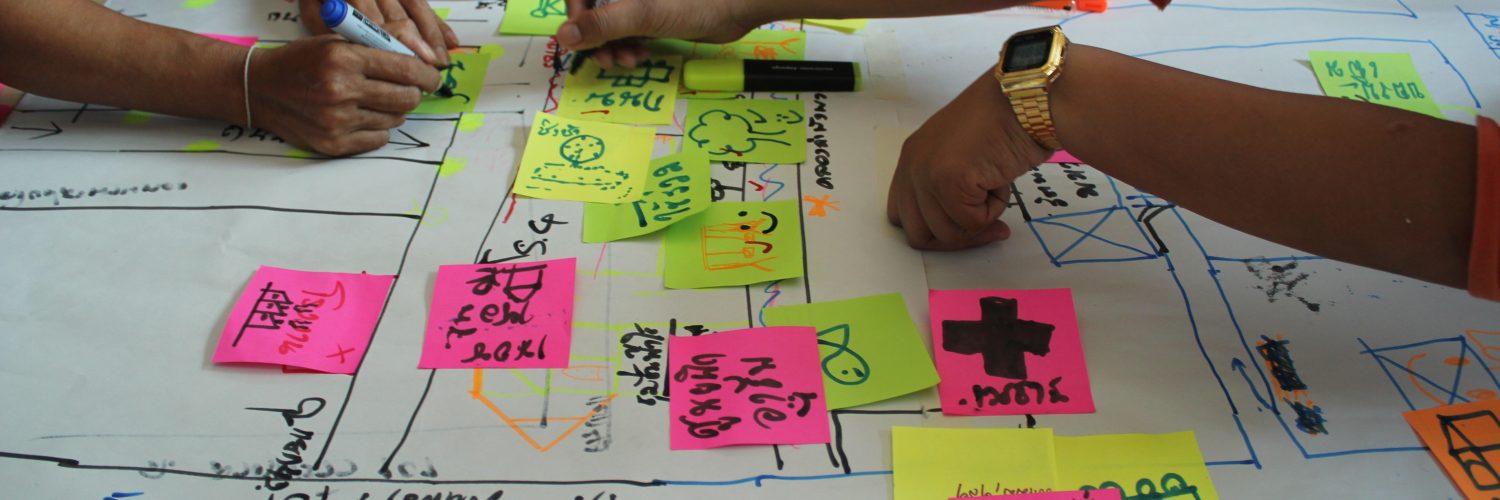
Bioregional mapping is a community and participatory process to create maps that combine ecological and physical information with social and cultural information within a given place, as defined by those living there or the communities most impacted. It is both a tradition that dates back thousands of years, inspired by countless forms of Indigenous Mapping, and also that has emerged as a direct and modern response to the erasure of local cultures in the face of our current ecological, economic and social crises.
While not every map will be at the scale of a bioregion, if you extend mapping beyond the parcel level or from a national or arbitrary boundary to a neighborhood, natural, watershed or other region that shares biological and cultural boundaries, you are creating a bioregional map.
Bioregional mapping is the art of making people care.
The goal of bioregional mapping is to help humans collectively re-inhabit the continents and bioregions that they live within. It encourages lifestyles that are healthy and democratic, self resilient communities living within the a sustainable carrying capacity for their area, and more so working to actively regenerate their region and world. It is also a deeply personal tool, as a person charts their own experiences, getting to know their home places, and makes every person an expert, and a part of this process.
As a place based ethic, bioregionalism fundamentally challenges us to rethink our relationship to each other and the places that we live, not just along human made lines, but in ways that consider the interconnected whole; all inhabitants, not just the humans living within a place. Because of this, bioregional mapping is a fundamental tool of bioregionalism. With it, we can map our water comes from, different communities of inhabitants who might affected, who originally lived where they now do, where their food comes from, where their waste goes; local plants, animals and how these might change with the seasons.

While it seems simple, these first steps that a bioregionalists takes can be incredibly powerful, revolutionary to some. Most importantly, by helping someone to better know their home, it challenges us to reconceive how we relate to place, breaks down established mental and physical boundaries and if done properly, and most importantly, can get someone to care. By taking these first steps, we cease to be American or Canadian and become citizens of our neighborhood, our watersheds, bioregions and places that are meaningful to us.
Bioregional maps are effective because culture stems from the shared experiences and concerns that grow from sharing place. They employ the knowledge and wisdom gained from understanding experiences with niche ecosystems of place.
Beyond a map on a screen, or lines on paper, bioregional maps can be stories told around a campfire, sung, danced, quilted, painted, posted or however best communicates the purpose that participants want to communicate. One important feature is that bioregional maps are also often concerned with with time – stories from the past, things that people find important to share or groups that are making a difference today, and lastly mapping regenerative and sustainable futures that we want to see. From these community maps, we can create road maps to ideas that might not have existed before, with tangible steps for how to get there. Bioregional mapping tends to be concerned with everything that current mapping is not – everything left off of google maps, or in between the road maps of interstates, gas stations and fast food restaurants.
The plants, the trees, the animals, our stories and lived experiences. Everything that makes a place special. The last little batch of old growth in a neighborhood, the last hawthorne bush planted by your grandmother, the crazy lady with the chickens next door, the homeless encampment down the way, or colorful mural. Untold and forgotten histories of discrimination, genocide or earlier strategies of resistance more important than ever now to tell. Or maybe it’s the type of birds or fish that migrate with the type of season. The rivers that carry the fish, or the bushes that provide unique nesting for native bird species. Stories of the places that make living here special, that define what we think of as home.
Ultimately, we will never accomplish real change by working within the cartography of capitalism or the nation state, nor will we be able to achieve a future that we cannot clearly envision or articulate. Instead, new maps will be needed, and new processes that involve all of us required. Just as we must work to democratize the ways we live and the societies we live in, a new form of map making is needed.
By mapping our home places, and the things we find special, we challenge these perceived notions, and chart pathways to new realities and futures for how our society can live.


Add comment