The United Watersheds of America
In a lesser known footnote of United States history, there was a brief time after the civil war between the 1870’s and 1880’s in which new western states adopted into the union may have done so along watershed boundaries, rather than divided by politicians in Washington D.C. The idea was proposed by Major John Wesley Powell, a civil war veteran, ethnographer, and second director of the United States Geological Survey from 1881–1894.
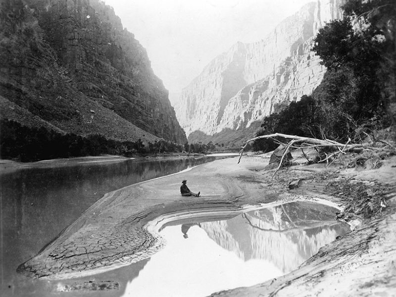
A professor of naturalism at Indiana University in Bloomington, Powell led the first two USGS government surveys down the Colorado River through the Grand Canyon in 1869 and 1872, filling in what was then a large blank spot in United States geography. While his first attempt down the river was ill fated and had to turn around, the second journey travelled with nine men in four boats for 99 days along more than 1,000 miles down along the then-uncharted Green and Colorado rivers, meeting many indigenous nations along the way, and became the first US exploration to follow it to its terminus in the Gulf of California. These expeditions of the arid watershed basins led to the most complete geologic study of the Western United States and his conclusion that any distribution of land not based on watersheds would ultimately lead to disaster.
Report on the Lands of the Arid Region
In the decades that followed, Powell would argue that careful, democratic management of water resources in the West must be a crucial component of its development and that a pattern of settlement and land cultivation based on the 19th century status quo would prove unsustainable.
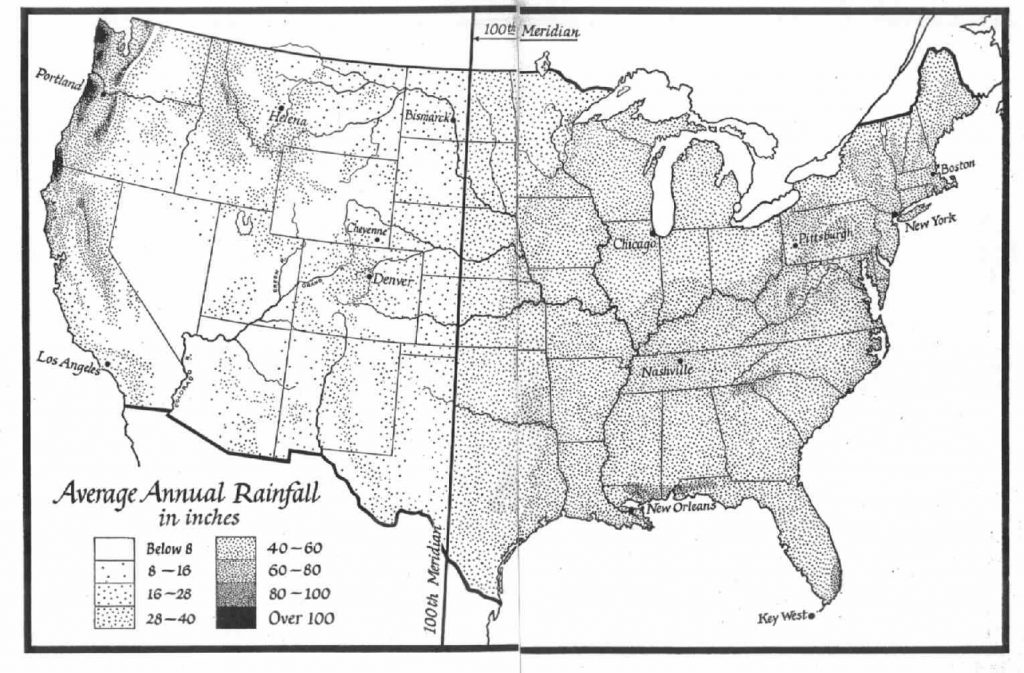
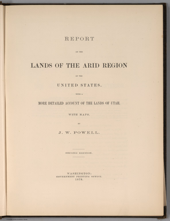
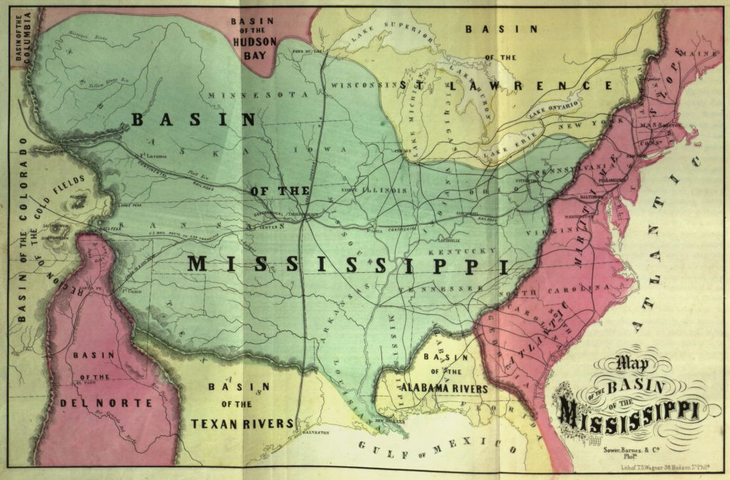
He observed that east of the Mississippi divided at the 100th meridian is commonly greener and more fertile than the west, and became one of the first geologists to ask what the difference might mean for the nation’s future and in 1878 he published his first “Report on the Lands of the Arid Region”, which was not only a general survey, but laid out a concrete strategy for settling the West without fighting over scarce water.
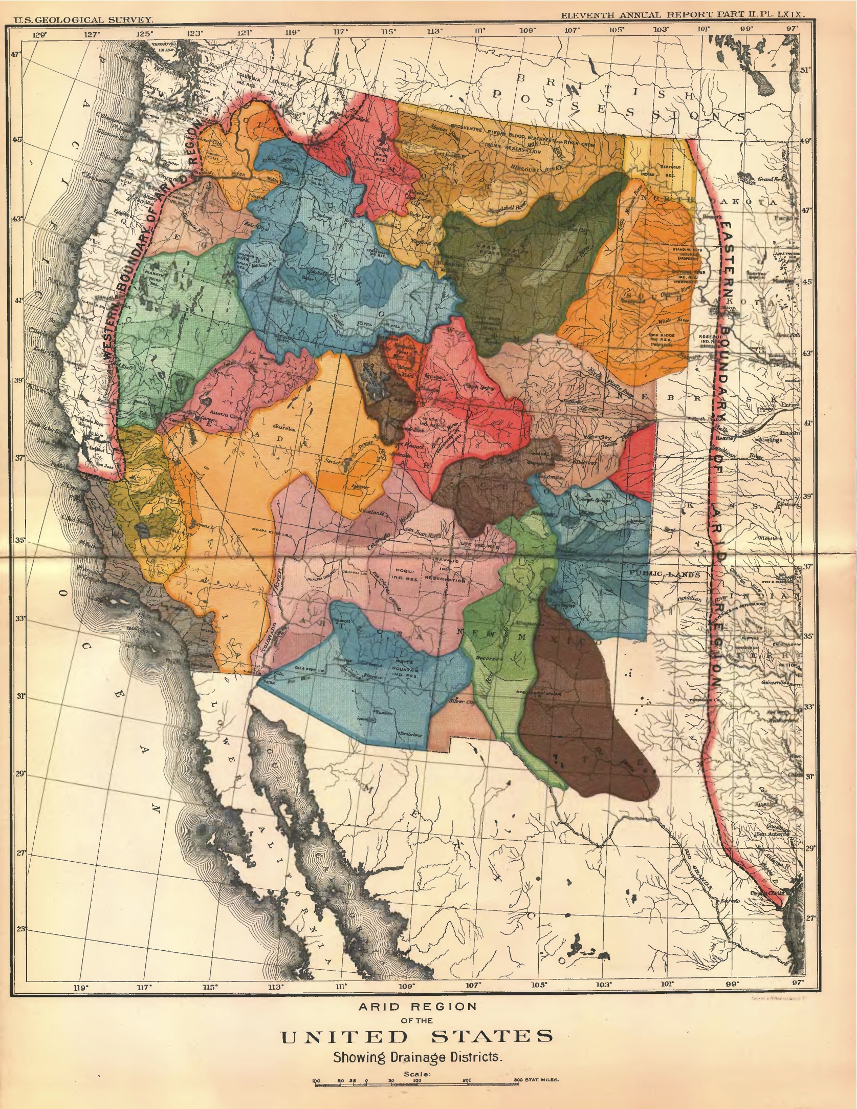
Powell suggested a new relationship to the distribution of water in the region in ways that would best serve all of its residents. Rather than the completely disorganized method for handing out huge tracts of lands through the homestead act, with many of the most arable parcels ending up in the hands of railroads or other large monopolies, Powell wanted to plan settlement around water and watersheds, which could locally and cooperatively manage water, creating communities better able to handle conservation, pollution, and keep the scarce resource from being diverted to other areas. Sorting states by watersheds allows each watershed based entity to make their own decisions around water usage, with the administrative power to enforce their policies, rather than having to fight for it. Growth and policy would develop where best suited, and those states would be able to use water within their own boundaries, rather than shipping water tens, even hundreds of miles away.
His idea rested on the observation that because the soil was too dry and poor to support agriculture at a scale common in the east, and because of the arid climate, statewide organization decided by any other factor would lead to conflicts over water in the future. However, if this decision making was shared by all of those living in the same watershed, growth and co-operation in those areas would be in line with what each could provide, rather than the complex bureaucracies we need today to maintain water, forestry and agricultural management. Water usage especially along the Colorado river is fraught with legal arguments by competing interests and areas, and are some of the most complex forms of interstate government and legislative challenges that face modern cities, counties, states and provinces in the United States today.
Along the Colorado River, this type of water usage is the subject of uncountable state vs. state lawsuits, strict rationing and increasing conflict between urban areas and agricultural industries. At that time, as the United States entered into the Homsteading Era in the decades after the civil war, the states of Kansas and Nebraska rapidly grew to over a million inhabitants by 1890, while the population of the 17 states and territories that comprised the American West grew to more than six million, already stressing some of the available resources. John Wesley Powell felt so strongly about his new plan that he proposed the idea that Western states should be brought into the union around watersheds, rather than arbitrary lines to the United States congress in 1879.
In response he called for more detailed hydrological and geologic studies and to consolidate all existing western surveys into a new comprehensive one. After many attempts to sway congress, they finally agreed, and in 1879 Congress consolidated the staff, efforts and funding of the four western surveys into the United States Geological Survey within the Department of the Interior, appointing Clarence King as the first director and Powell the director of the new Bureau of Ethnology organizing data he had collected on the western and southwestern Indian tribes he had observed during the years of his survey. On March 11, 1881, shortly after King resigned, possibly due to ill health, President James A. Garfield appointed Powell the second director of the USGS, a position he held along with the directorship of the Bureau of Ethnology for most of the rest of his public career.
In the Footsteps of Cartographers
These sentiments built on the words and works of another explorer, from nearly 60 years earlier, Stephen Long, who had travelled up the Missouri and Platte Rivers, travelling through what he called “the Great American Desert” and reaching similar conclusions. His writings were confirmed as the first climate and hydrology maps were released showing a continent split in two, divided by the Mississippi River: well watered to the east and dry to the west.
One of the most dramatic of these early hydrographic maps was created by William Gilpin, who was active from the 1840s to the 1870s, and sought to map not according to topography or political borders, but hydrography and watersheds, often created to help reinforce a point, or create a new and unique way of relating to our world.

At the time that Powell was just creating his initial findings, one of these maps circulated widely in the 1870s, using shades of blue to designate the severe absence of rain in the western interior. This map of rainfall areas confirmed to Wesley that the rush to settle the plains and beyond was a disaster in the making. It was also this visual evidence that inspired him to want to create his own maps propose an alternative path for western development. Congress was intrigued, and briefly renewed his funding for research toward a comprehensive plan of irrigation.
Rain Follows the Plow
Unfortunately, this way of thinking of the Western arid region of the US during the 1860’s and 1870’s stood in exact opposition to the dominant theories being espoused and that were used by the largest promoters of the homestead act. These included prominent geologists and climatologists, backed by the railroad lobby that “rain follows the plough”. This term was named for the discredited theory promoted by Charles Dana Wilber, created by noted climatologist Cyrus Thomas who suggested that agricultural development of land would hold more moisture, and change the climate to become more arable. This belief had developed in the early part of the 1860’s as white settlement had spread into Nebraska along the Platte River. Early settlers began to report that land that had been previously dry and brown during the summer, and become green in the seasons following irrigation and increased development. Cyrus and other early scientists concluded that the increase in rain and green vegetation was due to this expansion and the effect of cultivation, declaring that: “
God speed the plow. … By this wonderful provision, which is only man’s mastery over nature, the clouds are dispensing copious rains … [the plow] is the instrument which separates civilization from savagery; and converts a desert into a farm or garden. … To be more concise, Rain follows the plow.”
The notion was widely popular in the American West for its promotion and justification of industrialized expansion of the “Great Plains”, then known as the “Great American Desert”, as a solution for conquering and improving the existing environment. Railroad companies that had been gifted more than 183,000,000 acres / 740,000 km2 , most of which stretched narrowly along the tracks laid down, quickly latched onto the ideology, and vehemently disagreed with Powells idea. They aggressively lobbied Congress to reject Powell’s policy proposals and to encourage expansion, settling and farming in the arid regions so they could get the most value from the lands they had been given. Ultimately, it would not be until the disastrous failure of the dust bowl that the true impact of these policies would be felt.
At an 1883 irrigation conference, Powell would prophetically remark: “Gentlemen, you are piling up a heritage of conflict and litigation over water rights, for there is not sufficient water to supply the land. Despite congress largely ignoring his recommendations, was appointed as the second director of the US geologic survey in 1881, and made it his priority to undertake a systematic irrigation surveys of the western United States.
The United Watershed States of America
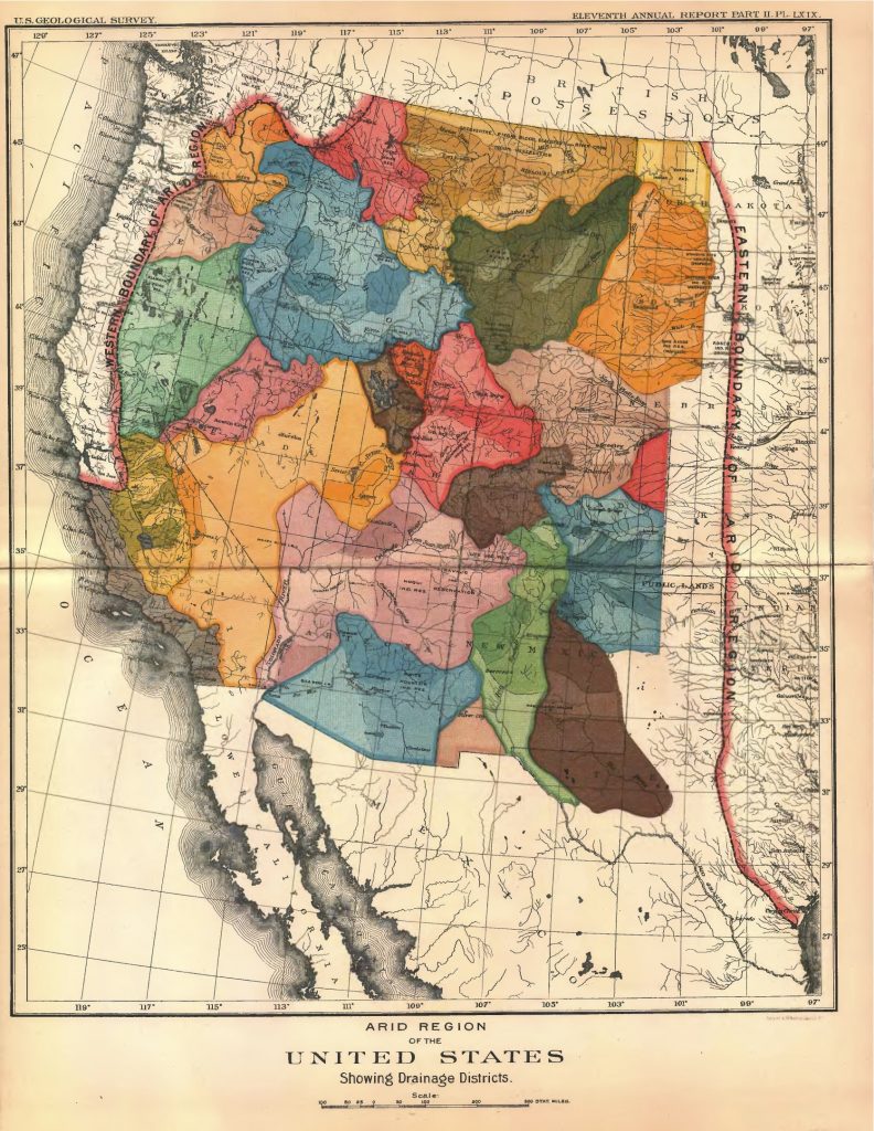
In the late 1880s, Powell undertook a large-scale survey of the far west to demonstrate that the region was made up of interdependent watersheds, or what he termed irrigation districts. On Oct. 2, 1888, after years of expanding the USGS, Powell obtained $100,000 from Congress for the USGS to begin a massive irrigation survey. The following year, Congress added an additional $250,000 for this project. Its purpose was to map in detail all the water sources and their drainages in the United States, with special priority for those in the West to identify a comprehensive plan for canals and irrigation. In the next two years he and his team measured the flow of water across one billion acres of land in order to determine the shape of the landscape’s most precious resource. They also found that while the Colorado River had a large volume of flow, since a large amount of the river wound through high canyons were unsuitable to traditional agriculture, and could not be replenished through water alone, and that the 160 acres provided under the Homestead Act was insufficient to not only support a family west of the Rockies, it was not even enough to support a single owner. As he began to work out these plans, he put into place prohibition of all new land requests through the Homestead Act in 1888, which was only partially enforced, leading to widespread confusion a rude shock of many of thousands of claimants. Worse, thousands of speculators followed surveyors as they staked out water sources, hoping to get access to the best properties. With access to prime real estate and water largely halted, Powells political enemies grew rapidly.
In 1890, Powell was called to testify before Congress about his plan to halt the rapid distribution of land through the Homestead Act. He argued instead for thinking more systematically about creating communities organized around the efficient use of water for the benefit of the most. He freely acknowledged his debt in this idea to Mormon colonies and the Mexican acequia system of community management.
For the logistics of development, he stated in the Report that small, local water districts were best. He proposed self-governing, cooperative groups of about nine ranches or farms whose occupants actually used the water. He further recommended political divisions, such as county lines, based on watersheds and the resulting use of water in those areas. Non-irrigable areas, he decided, should not be settled.
To drive home his point to Congress, Powell relied on several maps, including one of forests (the technique of mapping forests was itself new). But perhaps his most striking evidence was this beautifully colored patchwork map of western watersheds.
But Powell’s vision, however compellingly presented and argued, was simply too far removed from contemporary interests and assumptions about growth. But for all his conviction and evidence, Powell failed to convince enough members of the committee. While a minority report endorsed his vision of an alternative blueprint for settlement of an arid west, the majority rejected his recommendations and continued to distribute land for farming in the way that they had for decades. It didn’t help matters that he was stubborn, and exuded the passion of an evangelist that rubbed many Senators the wrong way. Soon after his testimony, the Senate shut down Powell’s irrigation survey.
Congress cut all funding to the irrigation survey in late August 1890, at the same time reopening land for settlement. The irrigation survey had lasted slightly less than two years.
Watersheds Today

As if to illustrate his point, three months before Powell died in 1902, Congress launched a century of massive dam and canal construction costing billions of dollars, all subsidized by the federal government. That fueled homesteading and corporate mega-farms. Cities snapped up water rights and imported water across hundreds of miles. Small farmers were overwhelmed by urban and corporate interests. And more water was promised than was sometimes available, triggering water wars.
This type of thinking today seems especially prescient. States like Arizona, Colorado, Nevada and Utah have seen drought conditions that have stretched on for decades, and left some of the largest sprawling metropolitan areas such as Phoenix, Denver, and Los Angeles, must battling for increasingly scarce water resources, and bring in water from ever further away. Lake Mead and Lake Powell (named after Major Powell), the two largest reservoirs in the country that sit along the Colorado River are losing more water each year than can be replenished, and where once the Colorado flowed into the Gulf of California at a roaring rate, now the river does not even reach the ocean in most years. And increasing climate instability are only adding to these trends.